Azamgarh, Uttar Pradesh
The district is named after Azam Khan who founded Azamgarh on the ruins of the village Ailwal and Phulwaria about 1665 A.D.
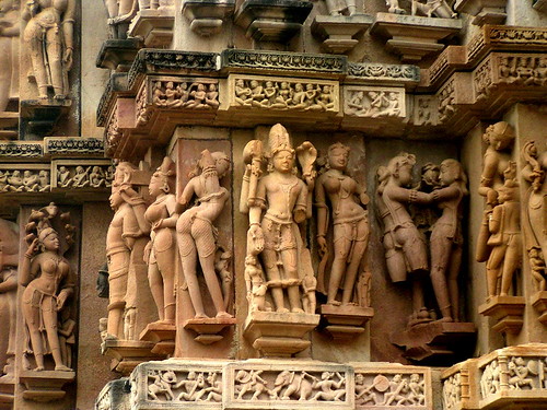
History of AzamgarhAzamgarh once formed a part of the ancient Kosala kingdom. Kosala figured prominently among the four powerful monarchies of northern India during the time of the Buddha. Azamgarh hardly possess any remains of much antiquarian value. In every tehsils of this district are some deserted sites, forts and tanks.
In the ancient times, Azamgarh was inhabited by old indigenous people like Bhars, Soeris and Cherus who represented the descendants of the aborigines of this area. Relics of numerous embankments, tanks, caverns and stone forts are found in this district which still bear out their energy and skill.
According to myths, a Rajbhar chief named Asildeo is said to have lived in the tehsils of Dihaduar(in Azamgarh). It is said that old tanks and mounds at that place are said to be signs of his power. The Bachgoti Rajputs of Arara in Azamgarh claim him as their ancestor.
According to another tradition, Parikhit, the eldest son of Kuru, once occupied the tract, now called Nizamabad and old fort (at Anwank) near which the battle was fought between him and the Muhammadans. It is supposed that the headquarters of the Bhars may have been in pargana.
The second battle of Tarain in 1192 A.D established Islamic power in India, but the region including the district of Azamgarh does not appear to have gone under the sovereignty of the Muslims. In 1193 A.D the district of Azamgarh passed into the hands of the Muslims. From the establishment of the Jaunpur kingdom to its extinction, most of the tract now included in this district fell under its rule. No important place in the district of Azamgarh can be mentioned as having been the seat of administration. It was in 1665 AD, that Azam Khan founded Azamgarh. After the attack of Chabile Ram, Azam Khan fled northwards with his interior forces. In 1675 AD, he died at Kannauj.
In 18th century, Azamgarh was included in the sirkars of Jaunpur and Ghazipur in the subah of Allahabd and was held by the Mohhabat Khan, popularly known as the Raja of Azamgarh. In his time the prosperity of Azamgarh was at its zenith. On September 18,1832 Azamgarh district was formed. After the struggle of 1957-58 no major events except the Gaurakshini or the anti-cow slaughter movement of 1893 occurred in the district till the close of the 19th century. It was in 1920, the Khilafat movement was started by Muslims to bring pressure upon Britain to change its policy towards Turkey. In August 1920, Mahatma Gandhi launched his famous non-cooperation movement, and the people of the district took part in it under the leadership of Suryanath Singh. In 1928 when the Simon Commission visited India, demonstrations were held against it and the people waved black flags and banners with words, "Simon, Go Back".
Mahatma Gandhi visited Azamgarh on October 3, 1929 to address a meeting of 75,000 persons and also said of the need of uplifting the Harijans and the prohibition of foreign goods. He instilled in the citizens a strong sense of national feeling.
January 26,1930, was declared as the Independence day by the Indian National Congress and thousands in Azamgarh, as elsewhere in India, repeated the solemn and inspiring pledge (of independence). In March 1993 Salt Satyagrah was started by Mahatma Gandhi. His arrest caused great resentment among the people of the district. The students of the local Wesely High School observed strike and the students and people of Azamgarh conducted huge processions against the British. The response of the people of the Azamgarh to the Civil Disobedience Movement was enthusiastic and British goods were boycotted and bonfires were made for foreign clothes and western style clothes. On July 4 1930 Gandhi Day was observed in the district condemning Mahatma Gandhi`s arrest. The news of arrest of Mahatama Gandhi and Vallabhbhai Patel on January 4,1932 led to widespread resentment in Azamgarh and hartals were observed everywhere. The Government retaliated by imposing section 144 Cr. P.C., issuing the press ordinance, the prevention of Intimidation ordinance, and the unlawful Instigation Ordinance and declared the Congress unlawful. Mahatma Gandhi launched the programme of individual satyagrah in 1940 and the people cooperated with him enthusiastically.
Azamgarh was in the front line of the Quit India Movement. The very day the district Congress office at Azamgarh was seized; and several arrest were made, the principal one being the arrest of Sita Ram Ashthana. During the night between the 11th and 12th August, a twenty-foot track of rail was removed from a point near Sarai Mir railway station by the people as part of their resentment.
On 14th August a large procession proceeded towards the police station of Azamgarh, hoisting the tri-color flag. The people caught hold of the policemen and snatched their guns and assumed control of the police station. In this way the police station came under the possession of the freedom fighters. More than 380 persons of the district were detained in connection with the Quit India Movement and 231 were convicted and given various terms of imprisonment. On August 15,1947 the district celebrated the Independence Day of India with great zeal.
Geography of Azamgarh Azamgarh district is located in Uttar Pradesh. The district occupies an area of 4234 sq.km. The district is bounded by Mau on the east, Gorakhpur on the north, Ghazipur on the south-east, Jaunpur on the south- west, Sultanpur on the west and Ambedkar Nagar on the north-west. It is located between 25 º 38`` and 26º 27` North of latitude and the meridians of 82º 40 ` and 83º 52` East of longitude. The height of the district from sea level is 77.65 mt.
The district of Azamgarh comprises a somewhat irregularly shaped tract of country lying south of the Ghaghra river, between the parallels of 25 degree 38 seconds and 26 degree 27 minute North latitude and the meridians of 82 degree 40 minute and 83 degree 52 minute East longitude. The river Ghaghra separates the district from the Gorakhpur. The river originates in the mountains of Kumaon and Nepal and is formed by the combination of waters of the Chauka, Kauriala, Rapti and many smaller streams. It swells during the rains to an immense size, when its current becomes very rapid, and damage from floods is often severe.
The other rivers that flow through the district are Tons (Tamasa),Choti Saryu, and Tamsha. The lakes found in the district are Kotail, Jamuawan, Gumadih, Kumbh, Pukh, Asaune and the largest of all of them is the Gambhiran. The district is plain without any hills, the only variations in the surface is caused by the Bad Lands along the streams that drain it. The country slopes gently towards the southeast. Here and there are found depressions of varying depth and extent in which the surface drainage of the interior collects.
The climate of the district is moist and relaxing except in winter and hot seasons. The year may be divided into four seasons. The period from March to the middle of June is the hot season. The southwest monsoon season which follows continues up to about the end of September. The succeeding period lasting till end of November is the post monsoon or transition season. The period from December to February is the cold season. The average annual rainfall in the district is 1021.3 mm. and it varies from 979.1 mm. at Deogaon to 1060.4 mm. at Azamgarh. On an average, in a year there are 50 rainy days.
Government and Politics of Azamgarh In Azamgarh, the total number of Lok Sabha Seats is two. The total no of Rajya Sabha Seats is three. The total number of Assembly Seats is ten.
The Government provides a number of schemes to its citizens as: old age pension scheme, national family welfare scheme, national mother welfare scheme, SC/ST Utpidan and Punarvas Anudan Yojna, SC/ST Sadi/Bimari Anudan Yojna, SC Scholarship Scheme, Bimukt Jati Scholarship Yojna, SC Shulka Chatipurti Yojna, Self Employment Scheme For Sc, Sanitary Mart Scheme, Widow Pension Scheme, Widow Marriage Award, Handicapped Scholarship Scheme, Minority Scholarship Scheme.
Medical and public health services provided by the government are: Maternity and child welfare scheme, Family Planning, Epidemics (Plague, Cholera, Smallpox etc.) Control Schemes, Primary Health Care Schemes, Polio Immunization, Malaria and Filaria Control Measures, Prevention of Food and Drug Adulteration, Leproscopy Control Schemes etc.
Development Schemes provided by the government are: District Plan, 20point Programme, Swarn Jayanti Swarojgar Yojna, Jawahar Gram Smraddhi Yojna, Training for Rural Youth Self Employment Scheme (TRYSEM), Integrated Child Development Scheme (ICDS), Special Component Plan, Development of Women & Child of Rural Area (DWCRA), Ambedkar Gram Development Scheme, Sunishchit Rojgar Yojna, Member of Parliament Local Area Development Scheme, Vidhayak Nidhi, Purvanchal Nidhi, Indira Awas Yojna, Bio-Gas Sayantra, Unnat Chulha, Gramin Payjal Yojna, Usar Sudhar Yojna etc.


 A multitude of cities and towns have developed in each and every state of Indian subcontinent. In the state of Uttar Pradesh also, there is no dearth of cities and towns. One such important city is Kairana. A municipal board has been set up to look after its administration. Kairana has been located in the district of Muzaffarnagar of the same state of India.


 standard of 59.5%, it has a number of primary schools and colleges. Gulab Singh Degree College is a well-known government degree college. There is one major inter college- Hindu Inter College, Chandpur. Father Son Public School is a well known English medium school of the area.The young generation of this town is very ambitious and working in many metro cities of India like Delhi,Noida ,
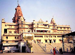
 Places of interest in Mathura
 During the time of Buddha, Kausambi was the capital of `Vatsa Janpad. Kausambi was then ruled by King Parantapa and after him reined his son Udena. Kaushambi holds the distinction of serving Lord Buddha, in the 6th and 9th year after his enlightenment. It is the place where Buddha delivered a number of sermons, thus elevating it to the status of a learning center for Buddhists.
  Pottery making, which was one of the oldest industries of the district, still contributes substantially to the economic life of the people. The fancy pottery made in Nizamabad is famous in the world. The potters make teapots, sugar-bowls and other decorative articles. The earthenwares and statues of Gods and Goddesses particularly of Ganesh, Laxmi, Shiva, Durga and Saraswati are also made. These products fetch rich market during fairs and festivals.
  The government of Azamgarh is concerned in providing quality education to its citizens. There are 2192 primary schools, 165 Higher Secondary Schools, 16 Degree Colleges. There is also a medical college and a polytechnic center. At present there are no engineering colleges at Azamgarh. The Government is aiming at Total Literacy Campaign. Post Literacy Campaign has also been sanctioned.
  Azamgarh is rich in cultural and religious activities as the district lies in the eastern part of Uttar Pradesh . The tradition language of the district is Bhojpuri and Purvi. The major community belongs to Hindu religion and they are divided into 4 branches as Brahmin, Khatriya, Vaisya and Sudra. The principal deities worshipped by the people are Brahma, Vishnu, Shiva, Laxmi, Ram, Hanuman, Ganesh and nine forms of Devi(Durga), viz, Shailputri, Brahmcharni, Chitraghanta, Kusamandini, Skandmata, Katyayani, Mahagauri, Kalratri and Sidhmata. The practice of taking a holy dip in river is also famous. The sacred books are Vedas, Upanishads, Geeta, Shrimad Bhagavata, Puran and Ramayan.


 The district of Etwah was earlier filled with wastelands. In 1888, it was Mr. Fisher, the then collector of Etawah pioneered the protection of land from erosion by planting forests. This forest is said to be largely responsible for saving Etawah city from the erosive action of the Yamuna. The Total forest area of Etwah is 301.04 sq. km, which constitutes 12.52% of the total geographical area. The flora of Etawah district comprise 560 species out of it 123 species are medicinal plants like Arjun, Neem, Bel, Indra Jav, Babool and Arvsa.
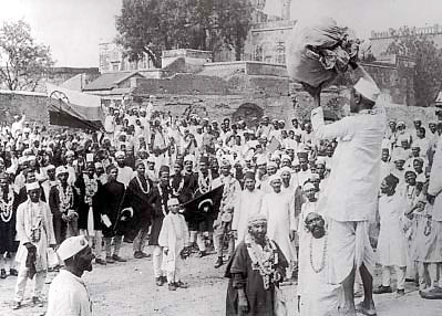 When Gandhiji emerged to the forefront after returning from the first session of the Congress that was held at Lucknow, a large number of people came to the forefront to take part in the freedom struggle. The national movement had so far been confined to the urban intelligentsia but his appearance on the Indian political scene gave a new direction and meaning to the freedom struggle, which was now carried to the masses. In Etawah a large number of persons enrolled themselves as volunteers.
 As per the 2001 India census, Barhalganj has a population of 19,171. It is at a distance of 58 kilometers from the Gorakhpur district. Males and females respectively constitute 52% and 48% of the population. The average literacy rate of the town is 60%, higher than the nationwide mean of 59.5%. 58% of the males and 42% of the females are literate. 16% of the population is children under six years of age. Barhalganj has one postgraduate degree college under the Deen Dayal Upadhyaya Gorakhpur University. There are also many private hospitals. The notable religious places of Barhalganj are the hanuman mandir, the muktipath and the jaleswar nath. Muktipath is a place related to the Hindu cremation process. Barhalganj is also famed for its saree markets.
 Near Gezing is the ancient town of Yuksom, the ancient capital of Sikkim built in 1642. Other attractions include Pemyangtse monastery built in 1640, reputed to be Sikkim`s oldest and Khecheopalri Lake which as legend has it not a leaf is allowed to float on the surface. The town is the base for trekking in the Himalayas and professional expeditions to Mount Kanchenjunga.
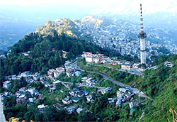
 British during the `hey day` of the empire, and reached by a branch road from the Kalka-Shimla road. The quite beautiful hill-station of Kasauli has a Pastur Institute that produces the anti-rabies vaccine against mad dog-bite and, at the same time, treats victims who have fallen prey to the dead disease, Hydrophobia. The institute in Kasauli set up in 1900, is the oldest in India, taking care of pet, police and army dogs as well as their masters. Side by side another institute produces other vaccines, this is the Central Research Institute affording immunity from Typhoid, small-pox, cholera and snake-bite. The Shimla Hills stand on water - parting between the Sutlej and the Giri, a tributary of the Yamuna.


 It is surrounded by the Dhemaji district on the north, the Tinsukia district on the east, the Tirap district of the state of Arunachal Pradesh on the south-east and the Sibsagar district on the north and south-west. The entire region extends from the north bank of the mighty Brahmaputra River, which runs for a length of 95 km through the northern edge of the district, to the Patkai foothills on the south. Moreover, The Burhi Dihing, a major tributary of the Brahmaputra River flows through the district from east to west along with its wide network of tributaries and wetlands. Dibrugarh is well connected to other places by roads, railway, airway ( it has the Mohanbari Airport) and waterway. There are four airfields, which were utilised by the British to wage war against the Japanese forces in Myanmar during the second World War. Dibrugarh is home to the world`s largest area covered by tea gardens. The whole district is enclosed by tea plantations and has tea factories. Many tea gardens date back to more than 100 years. In Digboi, another town of this district, there is the world`s oldest running oil refinery. The entire district has numerous oil and natural gas rigs possessed by the Oil India Limited and Oil and Natural Gas Commission. Tea and oil are the chief source of revenue for the district. The occupation of the majority of the people is farming. The main crops produced are rice, sugar cane and pulses. Many people are also engaged in pisciculture. There are many rice and oilseed mills, coal mining and petroleum production industries. The languages commonly spoken by the people of the district are Assamese, English, Hindi and Bengali. There are six main towns in the district, namely Chabua, Dibrugarh, Duliajan, Naharkatia, Digboi and Namrup. The police stations are located in the towns of Dibrugarh, Lahowal, Chabua, Joypur,
  Tengakhat, Naharkatia, Duliajan, Rajgarh, Moran, Khowang, Borboruah, Tingkhong, Rohmoria and Ghoramora. The district has been the main centre of higher education in the total North Eastern part of India right from the period of British rule in India. Dr. John Berry White set up the Assam Medical College after he became the civil surgeon of the Lahimpur district. The Assam Medical College set up in the year 1898 has the first Radiology department in India. Other centers for learning are the Dibrugarh University, the Dibrugarh Poly-technique and the Regional Medical Research Centre.
 also have tried to identify the true scenario of Nongthymmai town. Its average literacy rate is as high as 82 % and thus confirms that development has more or less occurred here. It is even higher than India`s average literacy rate, which is counted to be 59.5 %. Both male and female residents have developed inclination towards education and learning which is apparent from their individual high literacy rates. In other words, 84 % and 80 % are the rates of male and female literacy respectively.In Nongthymmai, children who are below six years of age constitute 11 % of total population.
